Monday, July 6, 2015

Final Thoughts

I want to take this opportunity to provide my closing thoughts on this trip now that I am back home.

First, I need to thank my wife Cathy for once again providing the opportunity to take an extended motorcycle trip such as this.  She keep things going at home while I am gone and was instrumental in getting my GPS issue resolved in a timely manner.  I know I am lucky/fortunate to have such an opportunity. Thank You!

Note: I have been able to do an extended trip every year since 2008. If you want to see any of my previous blogs here are the links:
 Second, I want to thank all of you for following my blog.  To me, the blog serves 2 purposes:
  1. The first is to help me remember my trips.  There is so much going on during these trips that if I don't write about each day as it happens, it all become a blur and blends together and I forget the details that really make the trips.  The blog also becomes a journal that I can go back to later to read and remember.  These trips are providing memories that will last a lifetime (or as long as the memory lasts!)
  2. Secondly, the blog allows family and friends the opportunity to follow my adventures.  There is no other way I can keep everybody up-to-date on what is happening and where I am at.  I get many comments every year from people saying how much they enjoy reading the blog and following along.  Some people may never have the opportunity to see and visit the places I have had the opportunity to go so this allows them to see these places through my trips.  For others, my experiences provides them the encouragement to go out and see these places on their own.
The route I created for this trip included many great motorcycling roads.  I received many comments about the number of curves when I showed people my route prior to leaving.  A few of the roads I had ridden before, but for many this was my first experience.  I must say I really enjoyed my selected route.  There are a few changes I would make if I were to do the trip over but in most cases, I wouldn't change a thing.  To me, having done the research prior to the trip to find great roads and creating the route provides more riding time once I am going rather than figuring out as I go. I know others prefer the exploration method - to each their own.

Below are a few of the hightlights of the trip to me:
  • Surprising my daughter in Manhatten Kansas
  • Crater Lake in Oregon
  • Death Valley
  • Yosemite
  • Mount St. Helens
  • The coincidence of meeting Jim (and Mary) and how it helped solve the GPS issue and their generosity and hospitality
Here is how I would summarize some of the places I went:
  • Beartooth Pass: Fun as always
  • Chief Jospeh Highway: Amazing views
  • Tetons: Young mountains, beautiful lakes
  • Idaho: Great canyon roads
  • Mount Rainer: Majestic
  • Mount St. Helen's: Unimaginable the power of the volcano to destroy a mountain
  • Oregon/California Coast: Beautiful
  • Crater Lake Oregon: Bluest water I have ever seen, cool looking into the mountain
  • Sierra Nevada Mountains: Sonora Pass has great views
  • Yosemite: Wonderful campsite
  • Death Valley: Amazing colors
 Here are some final statics regarding the trip:
  • Number of riding days:17
  • Total miles: 8,418
  • Average miles/day:488
  • States Ridden In: 15 (Minnesota, South Dakota, Wyoming, Montana, Idaho, Oregon, Washington, California, Nevada, Arizona, Utah, Colorado, Kansas, Nebraska, Iowa)
  • Total expenses: $1,425
    • Average cost/day: $83.85
    • 38% of expense on fuel: ($538)
    • 30% of expense on lodging (camping/hotels): ($431)
      • 2 nights in hotels
      • 3 nights at family/friends
      • 11 nights camping
  • Gallons of fuel:171
  • Average MPG: 49
    • Best tank MPG: 58
    • Worst tank MPG:41
That is all I have.  Thanks for following along.  I hope you enjoyed the adventure!

Saturday, July 4, 2015

Saturday, July 4 - Day 18: Back Home

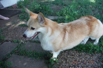
I was able to get the kids (daughters and grand doggies) assembled for a few pictures this morning.  In the front row (dogs - Einstein is on the left and Ros is on the right).  In the back row (daughters -  Lindsey who is the youngest is on the left and Trisha who is the oldest is on the right.)


Left to right: Einstein then Ros.


Einstein

Ros


I left Manhattan Kansas this morning at 10:00 a.m. and got home at 8:00 p.m. It is just about 600 miles.  I must admit my butt was getting a little sore on the way home.  Putting this many miles on today at the end of the trip was difficult but I wanted to get home tonight.  I did not have a specific route planned for the way home but used the GPS and shortest route as the method for most of the ride.  I also tried to avoid as much freeway as possible. Below is the my route for today.


I have most of the unpacking done but a few things remain.  I also have many projects I need to get caught up on that have stacked up while I have been away.  First thing tomorrow I have to go pick fresh strawberries to eat and freeze.  I almost missed the picking season bu there are still a few picking days left so I guess Sunday morning it is.

I will be posting some final comments and stats in the next few days (when I find time) so please check back soon.

Now it is time to get some sleep in my own bed for the first time since June 16. I have a feeling I will sleep well tonight.  Good night.

Friday, July 3 - Day 17: Surprise!

Surprise!  Today I was not actually heading across the Nebraska Sandhills as I put in my last post.  Instead, I was heading across Kansas to see my daughters in Manhattan (Kansas).  See, my oldest daughter (Trisha) and her husband John live there as she is attending KSU (Kansas State University).  My youngest daughter (Lindsey) lives near Phoenix, Arizona as she is attending ASU (Arizona State University) but she was flying to Manhattan to spend the weekend with her sister. The last time I saw Lindsey was at Christmas as we did a family Christmas in Phoenix.

When I was planning the trip, they had asked if I planned to stop by on my trip as I could see both of them at the same time.  I had said "no" because I wasn't sure how things were going to work out and didn't want to set expectations that I could not meet.  As I have been on the trip, in the back of my mind, I knew stopping by was a possibility if things went well and I was a little ahead of schedule.  A couple of days ago I told Trisha that I would be able to stop by and that I wanted to surprise Lindsey so we put together a plan.

Lindsey was scheduled to arrive in Manhattan around 3:15.  Of course her flights got messed up but after much work with the airlines, she did get other flights arranged and arrived around 5:20.  To arrive prior to my daughter, yesterday I did not stay in Colorado Springs but stayed in Burlington, Colorado which is near the Kansas border.  That left about a 4.5 hour boring drive across Kansas today.  I arrived shortly after 1;00 today.  I am not posting a map for today's route as the GPS directions said go 315 miles, turn left and arrive.

When they returned from the airport, I was in the house around the corner and let them both come in. Lindsey was greeted by Trisha's 2 Corgi dogs (Einstein and Ros).  As Lindsey was playing with them, I tapped her on the shoulder.  She turned around and was totally surprised to see me.  She had no idea.  The hug I received and the look on her face was priceless.

Saturday I should complete the journey and return home. Please watch for a final update with my closing thoughts and statistics from the trip.

Thursday, July 2, 2015

Thursday, July 2 - Day 16: Continuing Homeward

The main objective for today was to just keep getting closer to home.  I plan to arrive home on Saturday sometime.

As I was leaving the campground 2 items caught my attention.  The first was this gnarly old tree.  The second, was the biggest velvet rack I have ever seen on a deer.  Take a look.


I pick the following route out of Utah and across Colorado (675 miles).  From Capital Reef, I head north to catch I70 at Green River and take it all the way to Glenwood Springs Colorado (about 175 miles) and then head down through Aspen (terrible traffic), across Independence Pass (Continental Divide @ )12,095 feet) and over to Colorado Springs.  Again, there is so much good riding in both of these states but I need to stay focused on the objective.  I am glad I have had other opportunities to spend more time enjoying each of these states and what they have to offer.


It is nice to see the lush, green vegetation in Colorado versus all the brown and dry plants on the west coast.  On the west coast, the streams were barely running.  In Colorado, the rivers are raging and there is water standing in many places.  There is also more snow remaining in Colorado mountains.  This may be partially due to their higher peaks (which take longer to melt) as well as additional snowfall compared to the west coast.

Here are a couple of photos from Independence Pass.


I am still working on the route for tomorrow.  It will likely include the Nebraska Sandhills in some way.  I guess you will just have to wait and see what I come up with!

I did achieve a couple of mileage milestones today.

  1. I have now driven 7,500 miles on the trip!  I am averaging 492/day.
  2. The motorcycle now has over 10,000 miles on it!  Considering I bought it late October 2014 and only put 200 miles on it before the Minnesota winter made me put it away, I think I am off to a good start.  I have heard (not verified) the average registered motorcyle in Minnesota gets about 2,000 miles per year.  I guess that puts me WAY above average.


Wednesday, July 1 - Day 15: I Survived Death Valley and a Quick Utah National Park Tour

Yes I am still alive and well!  I just haven't had internet connection for the last couple of days to post updates.

To try and beat the heat today, I left my motel room at 4:45AM.  The plan was this would put me at the entrance of Death Valley about sunrise or a little after.  The temperature is about 80 degrees not too bad. I do a quick check of the radar and there is this large area of rain moving towards me and my destination.  It looks like I will miss most of it so I take off.  After all, I'm in the desert, how much can it rain?

I arrive at the entrance and it is still mostly dark. I take my photo and move on.


I am treated to a great lighting show as I continue.  Soon the wind  and rain arrives.  It rains pretty good for 10 minutes.  I don't put on rain gear figuring a little moisture now will help cool me later.  There are a few spots where the water washes sand/rocks across the road.  The roads are wet, I proceed with caution.  The descent continues - 4,000 feet to below sea level.  As I descend, the temperature rises.  However, with the storm and rain, the temperatures are very moderate.  The rain stops, the daylight slowly begins to appear.  I meet a snowplow in Death Valley; well it is a big truck with a snow blade on it just like a snowplow, but I think the driver is looking for debris that the rain had washed onto the road.   It turns out this was the perfect time to visit Death Valley.  The temperature was never above 95 degrees.  The forecast for later in the day 120+.


I drive out to Bad Water Basin (17 miles one way from the main road).  This is the only place in Death Valley that naturally has water.  The story is that the water is so bad (salty) that an early explorer's donkey would not even drink it so he named the place Bad Water and it stuck.  This is thee lowest place in North America - 283 feet BELOW sea level.  They have a sign hung on the side of the mountain at sea level; strange to look up to sea level.


I also do a loop called Artist Drive; the colors of the rocks are amazing.  I didn't not expect to see all these colors in Death Valley.


I depart Death Valley and leave California behind for this trip.  I head towards Las Vegas and stay north of the city.  It is 10:00AM and it is already 100 degrees.  How long can I last today?  At one point I really get concerned about the temperature. I am watching the read-out on my dash – the temperature just keeps going up.  110, 115, 120, finally 124. I think everything is going to melt down.  Suddenly I realize the read-out is not the temperature but actually a mileage counter. Silly me.  I change it to the REAL temperature and it is only 104. I feel cooler already. This is the first time I thought 104 was cool! The temperature from about 10:00AM until 2:00PM varies between 100 and 104.

Outside of Las Vegas I did see both unmanned/drone military planes flying as well as 2 fighter jets taking off.  Pretty cool.

As I cross Nevada, I go through Area 51 which is known for ET (Extra Terrestrial) and UFO (Unidentified Flying Objects) activity. It is time to stop for gas.  I see these two business side by side. I decide to stop for some out of this world entertainment! Just kidding.


I also really liked having the CamelBak.  It definitely helped keep me cooler and better hydrated.  Too much so actually.  I found out I had to reduce the amount I drank otherwise I was stopping every 100 miles or so to empty one tank (bladder) long before the other tank (fuel) needed filling.

Next I leave Nevada for the last time on this trip.  I then cross the northwest corner of Arizona.  I think it is less than 50 miles and now I am in Utah.

Around 2:00PM the temperatures start to moderate and fluctuate.  They range from 70 to 100 the rest of the afternoon depending on altitude and cloud cover. 

In Utah, I do a quick drive by many of the National Parks. Zion (which I actually drove through), Bryce (which is still my favorite!), Grand Staircase - Escalante, and Capital Reef.  I did not stop and take many pictures in these parks as I did that on my trip last year.  If you want to see photos, you can see my blog from last year at Rettigtrip2014.blogspot.com.  I know many will be disappointed that I did not spend time in each of these wonderful parks. As this trip is about the west coast, AND I am only passing through due to limited time, AND the fact that I have recently visited these parks, AND today was about heat management AND putting on miles to get back home; decisions and trade-offs need to be made.

Here are a few photos from each place:

Bryce:

Grand Staircase:
Capital Reef:


I am spending the night at a campground in Capital Reef National Park. My tent is under an apricot tree (another first) and I have a great view of the red rocks in this Park.


Here is my route for the day.  I drove in 4 different states today.  On this trip do far I have driven 11 states (in order): Minnesota, South Dakota, Wyoming, Montana, Idaho, Oregon, Washington, California, Nevada, Arizona, and Utah.